One day, while still on the cruise portion of the journey, we left the ship via a large hole in its side, and boarded a catamaran. Then we headed up a long, narrow inlet called Tracy Arm. The destination was the Sawyer Glacier, both north and south branches of it. A hundred fifty years ago or so, Sawyer Glacier was a single mass of ice, stretching far into Tracy Arm. It has gradually receded, although the main mass of it is still moving forward. It is now divided into two branches, which were split as it receded into two separate channels of underlying rock base.
The day was rainy, which made photography difficult, but also made for numerous beautiful waterfalls along the way. We headed first toward North Sawyer, where the catamaran sat surrounded by ice, both larger chunks of actual iceberg and the small, floating pieces known as 'bergy bits'. (honest! That's the scientific name for them.) While at North Sawyer, we were treated to the sound and sight of fairly good sized chunks of ice calving off the face of the glacier. But our real treat waited for us at South Sawyer. South Sawyer was very busy that day. At one point, a huge slab of ice detached itself from the face to slide down into the water below.
So put on your warmest sweater, some mittens, a cap, and cover it all with a rain poncho and come along!
 | |
| We actually spotted our first glacier before leaving the Volendam, just a bit before the ship turned into the entry to Tracy Arm |
 |
| A valley that has been carved by a glacier will have a pronounced "U" shape, whereas a valley that is the result of other forces, such as seismic activity will have a "V" shape |
 |
| Ice formation in the water |
 |
| North Sawyer glacier from 1/4 mile away. The closest boats are allowed is a quarter of a mile because of the risk of subsurface calving, which can send huge slabs of ice shooting to the surface without warning. |
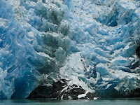
The face of the glacier. The deep blue colors are caused by compression. The deeper the blue, the less oxygen there is trapped in the ice.
 |
| Rock faces along Tracy Arm. The various rock colors are from different mineral deposits. The milky tone of the water is from glacial silt. |
 |
| The black dots are a colony of sea lions, which begin to give one a sense of scale. All of the ice floes are much larger than they appear at first. |
 |
| A sea lion in the water. Note the heavy concentration of silt here, which indicates both proximity to the glacier and the amount of calving going on |
This had been an extremely rainy summer along The Inland Passage. Most years, there aren't nearly this many waterfalls and even in this year, they tend to disappear between rain storms.
Views along Tracy Arm
Calving
Next stop: Juneau


No comments:
Post a Comment